
Farm Lane Road summer utility work
Farm Lane Road
–
Road closure
Summer lane reductions or closures to allow for utility infrastructure to be installed and updated over the summer. This work is part of the Farm Lane Road and Utility Reconstruction which connects utility services to new buildings and increases reliability of utility services on campus. Impacted road segments include:
- Farm Lane Road between the N. Shaw Lane and Wilson Road
- S. Shaw Lane between Red Cedar Road and Science Drive
- Wilson Road between Red Cedar Road and Bogue Street
This is a phased project with road, sidewalk and parking lot closures happening throughout.
April 6 – May 4, 2026 - Wilson Road
Wilson Road between Red Cedar Road and Farm Lane Road
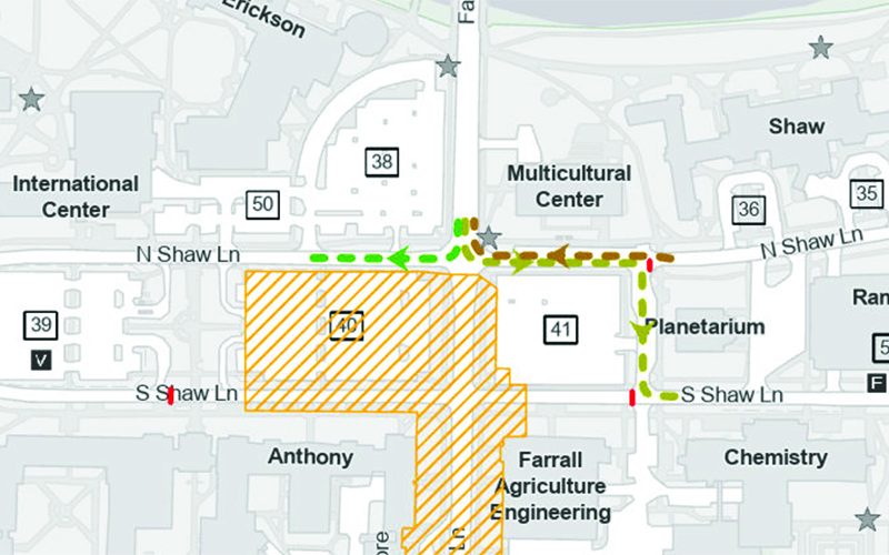
May 4 through August 21 - Shaw Lane & Farm Lane
Detour for eastbound traffic from Farm Lane to S. Shaw Lane
Two-way traffic on N. Shaw Lane ONLY between Farm Lane (near Multicultural Center) and Science Drive (near the Planetarium).
From the north side of campus heading east:
- Turn left (east) from Farm Lane onto N. Shaw Lane via temporary two-way traffic arrangement to
- Science Road (Lot 41 / Planetarium)
- Turn right (south) onto Science Road (between Lot 41 and the Planetarium) to S. Shaw Lane
- Turn left (east) onto S. Shaw Lane
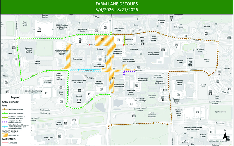
May 4 through August 21 - Wilson Road, S. Shaw Lane and Farm Lane Road
Wilson Road between Red Cedar Road and Bogue Street
Farm Lane between N. Shaw Lane and Trowbridge Road
S. Shaw Lane between Chestnut Road and Conrad Road
- Roads closed to thru traffic on Wilson Road, S. Shaw Lane, and Farm Lane Road.
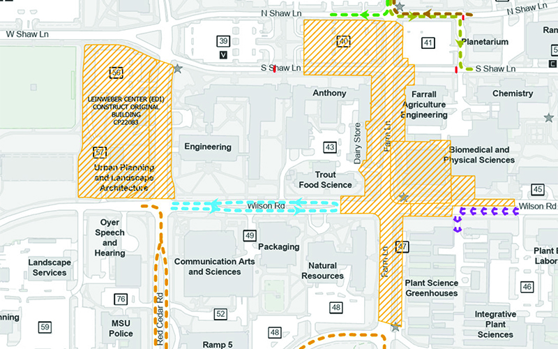
- Parking lots closing 5/4-8/21: Lot 40, Lot 42, Lot 47 and barrier-free parking loop at Natural Resources. The parking loop will reopen on 6/22.
- Temporary two-way traffic access to Lot 43 and Lot 49 from the west side of Wilson Road.
- Temporary two-way traffic access to Plant Sciences Greenhouses from the east side of Wilson Road.
- Some sidewalks will be closed and signed detours will be provided around the job site on the major trunklines.
See map for details. View PDF of the map.
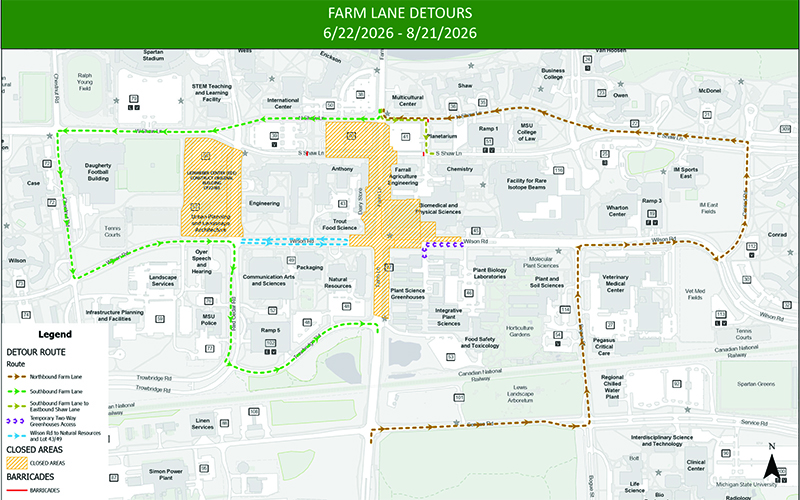
June 22 through August 21
Wilson Road between Red Cedar Road and Bogue Street
Farm Lane Road between N. Shaw Lane and Trowbridge Road
S. Shaw Lane between Chestnut Road and Conrad Road
- Wilson Road in front of Packaging to Natural Resources access available.
- Barrier-free parking loop on Wilson Rd. in front of Natural Resources is available for use again.
- All other closures listed above remain in place.
June 22 through August 21
Farm Lane Road traffic detours through campus
From the north side of campus:
- Turn right (west) down N. Shaw Lane to Chestnut Road
- Turn left (south) onto Chestnut Road to Wilson Road
- Turn left (east) onto Wilson Road to Red Cedar Road
- Turn right (south) onto Red Cedar Road to Trowbridge Road
- Turn left (east) onto Trowbridge Road to Farm Lane Road
From the south side of campus:
- Turn right (east) from Farm Lane Road onto Service Road to Bogue Street
- Turn left (north) onto Bogue Street to Wilson Road
- Turn right (east) onto Wilson Road to Conrad Road
- Turn left (north) onto Conrad Road to E. Shaw Lane
- Turn left (west) onto E. Shaw Lane to Farm Lane Road
Please obey all construction barriers, mind all flagmen and patrol officers, and follow posted detours. Your cooperation and patience during this time is appreciated.
View updated detour maps anytime online.
Andy Linebaugh, project manager, at 517-243-0049 or linebau6@msu.edu or Contact IPF at 517-353-1760.
View the Farm Lane Bridge utility project page for more information.
Project Number: CP24079